Monday, October 31, 2011

24 for a Halloween peak

Today marked the peak of my training for the Overland Park, Kansas, Gobbler Grind Marathon on 20 Nov. 2011. I ran a 'reverse' route: instead of running from my house west of Charlotte to my destination a.k.a. my parents' place west of Grand Mound, thanks to a westerly breeze (and a husband willing to drive me) I flipped it.

 After heading straight north out of Grand Mound along county road Y54, I turned
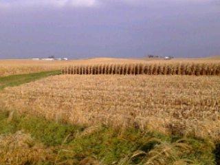
east toward Welton on county road E63 and was met with this lovely northern view.
Despite the darkening skies, it stayed dry the entire time. Yay!


Creeping closer to Welton, another fall vista north of county road E63.


St. Anne's Catholic Church in Welton. My mother's family used to have
a farm feed store in town and it was beyond nostalgic to run the familiar
horseshoe road past their old home and this church. My aunts used to ride
me around on the handle bars of their bikes...and occassionally dump me!


Since my mom had driven me to Grand Mound proper, thus shaving
2 miles off my intended route, I opted to add some sojourns. This was the
view from the backside of the old 7th Day Adventist settlement
(earmarked "North Welton" on our Iowa Gazateer).


Continuing north along the old portion of Hwy. 61 leaving Welton, I spotted
this old hidden bridge. The only means of spotting it is from this closed stretch of road.


The last portion of old Hwy. 61 north of Welton now abandoned, replaced by
a newer 4-lane version. As a means of accessing county road Y60 (the line of telephone
poles in the right corner), I climbed through a ditch and ran in the grass along
said 4-lane for about a quarter of a mile before crossing it and heading north toward Delmar.


Evergreen Cemetary on Y60 on the south edge of Delmar. Hey, it's Halloween...and the sun came out!


About 1.5 miles east of Delmar on state Hwy. 136, looking south.
Apparently an old railroad went right through where that pond now sits.


Another mile or two toward Charlotte on state Hwy. 136. That dark brown line is the abandoned
railroad bed of the aforementioned train. This "ridge road" offers lovely vistas.


A posse of tractors 5.5 miles west of Charlotte on 136.


Blair Witch, anyone?

Wednesday, October 26, 2011

Week 13--22 miles to Dad's

Following some knee trouble over the last 2 weeks (and backing waaayyyy off
the mileage) I opted to take a different  route to my dad's farm, taking advantage
of wider shoulders and awesome tailwinds. Next week, I'll peak at 24.5.
 About 6 miles into today's run south beyond the old county farm.

 When roads look like ribbons I think of RAGBRAI...and smile.

 Just a pretty little valley....

 ....followed by another. At the 10 mile mark, I headed east and worked the cross wind for 4.5 miles.

 
 The last of the hills heading east toward Elviria, Iowa, before heading back south.

 From beautiful hills to pancake flatness, I LOVE this route!!!

 Low traffic on Hwy. 30 toward Clinton, Iowa.


 Another example of why I love this time of year: John Deeres
pulling wagons of corn...this one down an on-ramp onto Hwy. 30.

With 3 miles left, this little guy thought I needed the 'what for'! He was crackin' me up
and helped me smile during the last miles of today's fun long run. Happy Wednesday!

Week 11: 23 to Dad's...or not

My Week 11 long run on 12 Oct. 2011 was supposed to be 23 miles.
Unfortunately Mother Nature had other plans and I was rained out by Mile 11.
I did another 7 on the treadmill at home. Oh well.


Those clouds and showers? Yup, I rain right into 'em!

15 Oct. 2011 weekender in Mpls

Was in Minneapolis for a dear friend's wedding and started the weekend
with an 11 miler along the river which divides Minneapolis and St. Paul. Oodles of
other runners out including the running of the "Gay 5k"! Was a fabulous morning
that left me thinking I may just have to return for the Minneapolis Marathon!

Doing the brief east leg of river trail.


Heading west on the West River trail toward the Mill Ruins.


Mill Ruins Park. A marvelous example of "urban archeology."


A view of downtown Minneapolis from the end of the West River trail.


Participants of the Gay 5k, an event to raise awareness for the legalization of gay marriage
in Minnesota. Sooooo wish I would've known about this ahead of time so I could
officially joined rather than banditted (a verb?) my way along with them.


Approaching St. Anthony Falls along the Stone Arch Bridge.


St. Anthony Falls


My favorite picture of the day, making my return pass through the Mill Ruins Park.


The memorial to the lives lost from the collapse of the I-35 bridge on 1 Aug. 2007.
It was a chilling, sober end to the day's run...and left me extremely grateful
none of the many friends and family that live in this area were directly involved.

16 Oct. 2011 weekender--Mpls Shorty

Just a little 3 mile morning run on Sunday 16 Oct. 2011 following the
previous night's most excellent wedding reception...
Heading from downtown Minneapolis over the West River.


View from a little trail off the beaten path...


From the bottom of the trail looking up the bank.


Heading out of said trail...gorgeous stuff, that Twin Cities. xo

Wednesday, October 5, 2011

Week 10: 21 miles to Mom's

Amazing that it's already Week 10 of training for the 11.20.11 Gobbler Grind, but the mileage is really ramping up. Kinda wish last week's LR had been longer. Today's mileage and rolling hills left me quite ragged. But it was super cool to run the route to my parents' place where I grew up! 
From where I start on State Hwy 136, the terrain is more wild and rolling compared to my destination. 


It's hard to see, but there are limestone walls under the bluff along County Road Z2E
(locally referred to as the Humeston). This little nook would be a kid's dream playland! 


The first of several creek crossings at Mile 4.


This Percheron was very patient as I tried to get as close as possible.


After climbing out of a valley, Mile 7 gave me one of my absolute favorite
spots along this stretch of County Hwy Z2E. Just beyond the bend to the right,
the road number changes from Z2E to Y70 and offers a direct route to DeWitt.
I, however, soon turned west on County Road E63.


Approaching the halfway mark at Welton is the busy crossroads of 
County Hwy E63 and US Hwy 61 in northern Clinton County. I continued west up that thar hill
where the rolling continued until turning south on County Hwy Y54 at Mile 14.


Y54's straight shot south to Grand Mound was so nostalgic,
given that I grew up in this area. It was so COOL 
running a road on which I've logged many, many bike miles.


Continuing south, the terrain quickly turns from rolling to pancake-flat with perfectly
square fields. This big, old lonely tree has been around forevah. And I like it!


Speaking of nostalgia, this farm was once home to a dog that LOVED to torment me
on my bike rides. I hated that beast! I saw neither hide nor hair of him today. (Good thing.)


One of my favorite groves of trees. You can't tell from the photo, but when you
bike or drive past, suddenly you see that this grove is made up of perfectly measured 
rows upon rows of trees. I always wonder who to thank for the effort...


Around Mile 17 I really began to fade so I started talking to the
grasshoppers like this little guy here in the forefront.


Opting to go gravel and reduce my mileage along busy US Hwy 30, Miles 18 & 19
were pretty taxing given the loose footing. I chalked it up to trail practice. 
Local farmers are getting busy with the bean harvest. Corn will be coming out soon!


 Ah.....my childhood Home Sweet Home.


Couldn't resist sharing my dirty, dusty legs!